

hhypiresia

The use of copyright is regulated by national, EU and international legislation, and by the Hydrographic Service’s policy, as established from time to time.
By signing the relevant agreements, the Hydrographic Service grants non-exclusive and non-transferable licenses for the use of its products and software . Breach of the relevant terms constitutes infringment of intellectual property rights or copyright, and legal remedies may be sought to protect these rights.
All material, including images, software, text and graphics, keys, keywords and labels, contained in the Site are copyright protected. Viewing and printing the contents of this site and distributing the documents it links to is permitted, provided that such documents will not be used for commercial or personal use, but solely for information purposes. The exchange, modification, sale, transmission or other commercial use of any information contained in this site is prohibited.
If any messages or material are sent by email or otherwise to this site, all such messages will be treated as non-confidential and non-exclusive, unless otherwise classified. The HS will have the right to freely use any concepts, ideals, learning methods or techniques that may be contained in messages sent to the site for any reason, without any compensation to the sender. However, the user agrees and understands that the HS will not be required to use any such ideas or material, and that the sender may not insist on any such use.
Αγγελίες για τους ναυτιλλόμενους (Hellenic Notices to Mariners)
Είναι οι πληροφορίες που παρέχονται με σκοπό να διατηρούν διαρκώς ενήμερους τους Ναυτικούς Χάρτες και τις Ναυτιλιακές Εκδόσεις. Οι Αγγελίες εκδίδονται από την Υδρογραφική Υπηρεσία και διατίθενται δωρεάν στο δικτυακό τόπο της ΥΥ: www.hnhs.gr.
Διακρίνονται σε :
α.Ετήσιες (Μόνιμες)
Εκδίδονται με ετήσιο τεύχος που κυκλοφορεί στις αρχές κάθε έτους, από την ΥΥ. Παρέχει πληροφορίες μόνιμης φύσεως (πχ πεδία βολής και ασκήσεων του Στρατού Ξηράς, Πολεμικού Ναυτικού και Πολεμικής Αεροπορίας, περιοχή έρευνας και διάσωσης της Ελλάδας, περιοχές δικαιοδοσίας ελληνικών σταθμών NAVTEX κλπ).
β.Αγγελίες για τους ναυτιλλόμενους (Μηνιαίο τεύχος)
Εκδίδονται με μηνιαίο τεύχος Αγγελιών που κυκλοφορεί στο τέλος κάθε μήνα, από την Υδρογραφική Υπηρεσία παρέχει πληροφορίες μόνιμης φύσεως (π.χ. θαλάσσιοι κίνδυνοι, ναυάγια, αβαθή, μεταβολές καταστάσεως λιμένων, λειτουργία νέων πυρσών, αλλαγή χαρακτηριστικών πυρσών κλπ) και πρέπει να καταχωρούνται στους Ναυτικούς χάρτες και τις Ναυτιλιακές εκδόσεις. Όταν απαιτείται (μεγάλες αλλαγές στα στοιχεία των χαρτών) οι αγγελίες αυτές συνοδεύονται από μικρά τμήματα χαρτών, γνωστά σαν «επικολλήματα» (BLOCKS) τα οποία πρέπει να τοποθετούνται (κολλιούνται) στον αντίστοιχο Ναυτικό χάρτη.
Για τις διορθώσεις των Ναυτικών Χαρτών πρέπει να χρησιμοποιούνται πάντοτε τα σύμβολα και οι επιτμήσεις του ΧΕΕ 64.
NAVTEX is an international offered Service aiming to the dissemination, in sailing ships, of navigational, meteorological and of urgent information that concern the shore sea areas. The information is gathered automatically and printed directly by telex.
NAVTEX establishment has been agreed, in common, by the International Organizations IHO (International Hydrographic Organization) and IMO (International Maritime Organization) (IMO Sub-Committee on RadioCommunications - 31st session - COM/31/5/4//13 Mar 1986 and IMO MSC 54 - COM/circ. 99//8 May 1987) and is a part of the Global maritime Distress and Safety System (GMDSS), which is developed inside IMO framework. The Greek NAVTEX Service belongs to the Mediterranean area NAVAREA III, whose coordinator is the Spanish Hydrographic Service.
NAVAREA III navigational warnings can be seen here.
NAVTEX International Service 518 kHz
For the implementation of NAVTEX International Service in Greece three (3) stations have been founded, after IMO approval, each one serving a specified sea area. Emissions are made by telex (type of emission F1B) in frequency 518 kHz in English language.
NAVTEX National Service 490 kHz
After a request made by HNHS and approved by IMO, on February 1st, 2012, the NAVTEX National Service was founded and set to order to the 490 kHz frequency in Greek language.
NAVTEX emissions are programmed to be made every four (4) hours, have a maximum duration of ten (10) minutes and are complied with the emission program issued by IMO.
Urgent and vitally important messages (i.e. search and rescue information, storm warning etc ) are emitted exceptionally.
The NAVTEX receiver must be activated at least twelve (12) hours prior the ship sailing or should remain operational constantly. It is programmed to receive automatically from selected station specific message categories. A computer controls receiving messages, so as they are not been reprinted in their entirety during the forthcoming emissions, but only their prefix.
All NAVTEX messages have a prefix consisting of a group of four (4) alpha numeric characters, B1, B2, B3, B4:
The first character B1 (letter) defines the identity of the emitting station.
The second character B2 (letter) defines the category of the message (as described below).
The third and fourth character B3, B4 (numeric) are the serial number of the message numbered from 01 up to 99. Subsequently, the numbering starts again from 01, avoiding valid NAVTEX numerics.
Exceptionally transmitted messages deemed to be necessarily received by the ships, get the serial number 00 in order not to be rejected by the receiver, but to be printed always, regardless of programming.
The second character B2 (letter) of the message prefix, suggests the category of the message where the following letters are being used (characters):
A- Navigationalwarnings.
B- StormyWindsWarning.
C- Icereports.
D- Search&rescueinformation.
E- Weatherreport.
F- Pilot service messages.
G- DECCA messages.
H- LORAN messages.
I- OMEGA messages.
J- STANAV messages.
K- Other electronic navaid messages.
L- Navigational warnings-additional to letter A.
Z- No message on hand.
The Greek seas services with NAVTEX messages issued in the English and Greek language (International and National NAVTEX Service) and are transmitted by three (3) Greek Stations installed in IRAKLEIO (35’ 19’ 19,7’’ – 25’ 44’ 54,9’’) with character [H], [Q], [S] respectively for the South Aegean, in KERKYRA (39’ 36’ 25,7’’ – 19’ 53’ 28,4’’) with character [K], [P] respectively for the Ionian Sea and LIMNOS (39’ 54’ 24,7’’ – 25’ 10’ 50,7’’) with character [L], [R] respectively for the Aegean. The area of service for each station as well as its limits are shown in the map entitled “GREEK NAVTEX STATIONS- AREA OF SERVICE”.
NAVTEX International Service 518 kHz
Emission hours of the aforementioned NAVTEX stations are:
HERAKLION [H]: 01:10 – 05:10* - 09:10* - 13:10 – 17:10* - 21:10*, UTC
KERKYRA [K[: 01:40 – 05:40* - 09:40* - 13:40 – 17:40* - 21:40*, UTC
LIMNOS [L[: 01:50 – 05:50* - 09:50* - 13:50 – 17:50* - 21:50*, UUTC
*Weather reports also emitted
NAVTEX National Service 490 kHz
Emission hours of the aforementioned NAVTEX stations are:
HERAKLION [Q]: 02:40 – 06:40 – 10:40* - 14:40 – 18:40* - 22:40, UTC
KERKYRA [P]: 02:30 – 06:30 – 10:30* - 14:30 – 18:30* - 22:30, UTC
LIMNOs [R]: 02:50 – 06:50 – 10:50* - 14:50 – 18:50* - 22:50, UTC
*Weather reports also emitted
NAVTEX National Service 4209,5 kHz
HERAKLION [S]: 03:00 – 07:00 – 11:00* - 15:00 – 19:00* - 23:00, UTC
HNHS has assumed the role of coordinator for the collection, processing and transmission, for further message emission by the NAVTEX stations that concern the Greek seas, with competent services the Hellenic National Meteorological Service (HNMS) and the Hellenic Coast Guard (HCG).
Exceptional Stormy Winds or Storm Forecasts are emitted immediately after their issuance.
For valid NAVTEX messages, please press here.

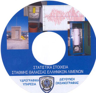
The Hydrographic Service maintains a network of permanent sea level recorders (tide gauges at ports in Greece’s maritime space to monitor changes to sea level). The stations enable the analog recording of any change to sea level, round the clock. The data are also recorded digitally (through ten-minute or fifteen-minute sampling) at selected stations and in the context of network upgrading, which enables phone transmission of the data in virtually real time. Also, the recordings of four stations (Piraeus, Katakolo, Syros and Kalamata) are directly available on the internet through the HS website.

In the future, all analog sea level recorders will be gradually replaced by electronic ones, which will be equipped with atmospheric pressure, temperature, salinity sensors and GPS. This is expected to reduce losses and upgrade the quality of observations by extracting direct data indicating how atmospheric (inverse barometer effect), thermosteric (rise of sea temperature), allosteric (changes in salinity) effects, and coastline movements (earthquakes, shifts of the crust of the earth) affect the level of the sea.
Sea level data in the form of hourly values are collected, processed and archived, while statistical information is also drawn about sea level in 23 areas of the Greek maritime space, in the form of monthly and annual statistics. The stations of the existing network provide the statistical data for the period from the 1990’s to date. These data have been compiled and issued (together with a local leveling network, area charts, etc) in the study “Statistical Data of Sea Level at Greek Ports” and are available for activities including:
Works in maritime cities : management of rainwater, sewage channels, etc.
Port works : port construction and deepening.
Commercial ports: safe sailing of ships, loading and unloading of goods.
Ship repair zones : lifting and lowering of vessels in repair and maintenance docks.
Provision of certified measurements to the scientific community for research.
CIVIL PROTECTION – Alert systems for hazardous and disastrous phenomena: alerts and forecasts of hazards owing to extreme weather conditions (extreme waves – meteorological tides) or to submarine geological phenomena (earthquakes – displacements – shifts of plates which could result in seismic waves -tsunami).
In the context of its participation in national and European programs aiming to develop and upgrade the network, the HS has participated or is currently taking part, through the Oceanography Directorate, in:
a) The ESEAS Program (European Sea Level Service- Research Infrastructure), 2002-2005
b) Memorandum of Cooperation between the HS/HN and the Dionysos Satellite Center of the National Technical University of Athens (NTUA), relating to the installation of four (4) sea level recorders and GPS stations in areas of national and surveying interest. In the context of this cooperation, the first integrated metering station was installed on the island of Megisti (Kastelorizo).
c) Climate Cosmos Program (Development of National Infrastructure and a National Web Portal in relation to Climate Change in Greece, following the Scientific and Technical Guidance of the United Nations and the Global Climatic Observation System,2013-2015) with the participation of the National Center for Sustainable Development (NCSD), the Institute of Geology and Mineral Exploration (IGME), the Hellenic National Meteorological Service, the 'Athena' Research and Innovation Center in Information, Communication and Knowledge Technologies
![]()
The Web Map Service (WMS) utilizes the data of the ENCs published by HNHS to generate images that are forwarded to end users over the Internet. The WMS will always offer updated images based on ENC data for allavailable scales (1:4.000 - 1:1.500.000). Please note that no vector data are forwarded via the WMS and that it is not suitable for use for navigation purposes.
The WMS is available from HNHS website only for chart viewing at scales 1:90.000 - 1:1.500.000, and for private and public agencies as cartographic background for the web applications they develop. Anyone wishing to use the WMS for this purpose must fill in the respective application and pay the fee established in the HNHS’s pricing policy for this service.
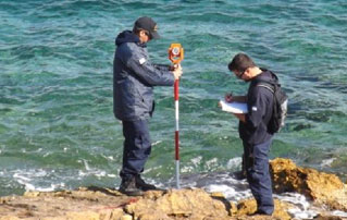
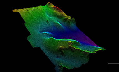
The Hellenic Navy Hydrographic Service, the official hydrographic agency in Greece, performs hydrographic works with the primary purpose of creating and updating official Greek navigational charts and publications. Further, it undertakes hydrographic works for the account of third parties, local port authority funds and various public entities. These works are undertaken at the request of interested parties to the HS. Once the HS has estimated the cost of the works, it proceeds to the signing of a contract which specifies the details of the worksite and deliverables.
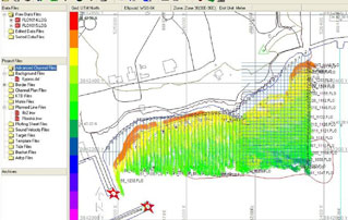
Hydrographic surveys include field collection and processing of data, preparation and/or updates of navigational charts and publications. These data include:
- Seabed depth and morphology
- Topographic mapping, and coastline and coastal area morphology;
- Details and positions of navigational hazards and obstacles (e.g. shipwrecks, dirty seabeds, submarine cables and wires, etc);
- Details and positions of navigational aids (e.g. lamps, beacons, buoys, known marks)
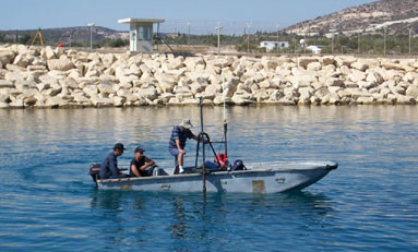
Field works are performed by hydrographic crews, comprising specialised scientific and technical, military and civilian staff. The staff are allocated to individual crews and board on hydrographic vessels, and also perform land geodetic and topographic survey tasks required.
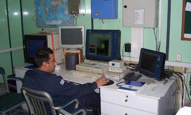
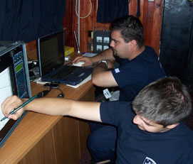
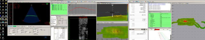
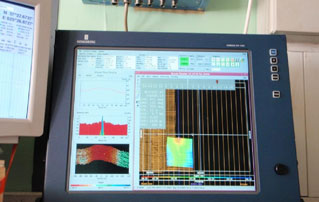
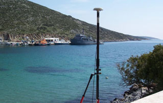
Key to the performance of hydrographic works is the special and suitably-equipped vessels. These are hydrographic ships for offshore sounding and boats for coastal areas, which are equipped with permanently installed, integrated hydrographic systems. These comprise:
- precise positioning system (GPS).
- single- or multi-beam echo-sounder.
- data collection and processing software that combines the position-depth data.
For very shallow areas, suitable portable systems are used which enable temporary installation on smaller boats.
Topographic works are performed to map the coastline and morphology of the coastal zone, and port infrastructures.
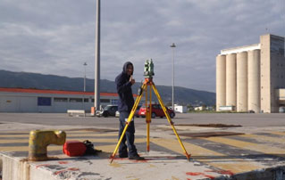
The geodetic works performed to incorporate all the above data in the map’s coordinates system are of paramount importance.
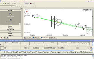
Subsequently, data processing takes place, where necessary reductions are made to map reference levels, appropriate corrections are implemented and quality control is performed. Finally, a bathymetric chart is prepared, which is used to produce and update the final products of the HS, and is kept in the records for future use.
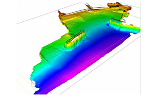
All works and data processing are carried out in line with the technical guidance of the International Hydrographic Organization (IHO). Such specifications have been incorporated in the standing Hydrographic Instructions given to the Hydrographic Crews.
In addition to Notices to Mariners, the Hellenic Navy Hydrographic Service (HNHS), also issues urgent information entitled ‘’HELLENIC NAVWARNS’’, which concern information about the safety of navigation.
For Navwarns main theme, please see paragraph 7.1 of Annual Notice Νο.13.
Navwarns do not replace the notice issued by HNHS or other navigational aids.
Navwarns are numbered throughout each year, by a serial number starting from 1, this number to be followed by the year of issuance (i.e. 1073/1999).
Navwarns are eliminated:
- Automatically (when they have a specified duration)
- By another Navwarn
- By a relative Notice to Mariner (in which the initial information of the Navwarn is included more fully and extensively), so the Navwarn continues to be transmitted for 15 days from the issuance of the Notice that repeals it, because it is estimated that within this time frame the diffusion of the Notice will have been concluded.
Navwarns are not printed and are not distributed as Notices to Mariners do, but, due to the emergency of situation, are been transmitted via Radiotelephony as follows:
- J3E type of transmission in Greek and English language by the following shore stations in areas as follows:
‘‘KERKYRA RADIO’’ (39o 36’ 25,7’’ – 19o 53’ 28,4’’) from the Ionian Sea until the meridian 22o 30’ 00’’ towards east (Patraikos and Corinthiakos bays included)
‘‘IRAKLEIO RADIO’’ (35o 19’ 19,7’’ – 25o 44’ 54,9’’) and ‘‘LIMNOS RADIO’’ (39o 54’ 24,7’’ – 25o 10’ 50,6’’) for the Aegean Sea between parallels: 34o 00’ 00’’ – 41o 00’ 00’’ and meridians 22o 30’ 00’’ – 30o 00’ 00’’.
‘‘RODOS RADIO’’ (36o 24’ 31,2’’ – 28o 13’ 37,1’’) for the South Aegean Sea between parallels: 34o 00’ 00’’ – 38o 00’ 00’’ and meridians 22o 30’ 00’’ – 30o 00’ 00’’.
The shore stations KERKYRA RADIO and LIMNOS RADIO are also transmitting the summary table of Hellenic Navwarns which are valid for the Greek seas.
Note: The call sign, the frequency, the time and type of emission and other attributes of the above stations, as well as information concerning the broadcasting of ‘‘Weather Report” and “Press Release” are provided in detail in the table of frequencies which is attached at the end of the document.
2. G2B / G3E type of transmission in Greek and English language for the Greek seas, by the following VHF transmitters of “OLYMPIA RADIO” Emitting Station
| Router | Position | Transmission channel |
Power (WATT) |
Navwarns Transmission hours UTC |
Navwarns Transmission hours UTC |
| KERKYRA | 39 44 54 - 019 52 20 | 02 | 50 | For the area of the Eastern Mediterranean and the Black Sea 06:00 10:00 16:00 22:00 |
|
| KEFALLINIA | 38 08 28 - 020 39 31 | 27 | 50 | ||
| PATRA | 38 14 47 - 021 46 07 | 85 | 50 | NO | |
| PETALIDI | 36 55 45 - 021 51 32 | 83 | 50 | ||
| KYTHIRA | 36 15 57 - 023 02 50 | 85 | 50 | ||
| MOUSTAKO, CRETE | 35 18 28 - 023 36 35 | 04 | 50 | NO | |
| KNOSSOS, CRETE | 35 16 52 - 024 56 08 | 83 | 50 | 05:00 11:00 17:30 |
|
| SITEIA, CRETE | 35 04 14 - 026 11 32 | 85 | 50 | ||
| RODOS | 36 16 22 - 027 56 01 | 63 | 50 | ||
| SYROS | 37 27 27 - 024 55 37 | 04 | 25 | 23:30 | |
| PARNITHA | 38 10 16 - 023 43 39 | 25 | 50 | ||
| PILION | 39 24 16 - 023 03 07 | 60 | 50 | ||
| CHIOS | 38 22 34 - 026 02 44 | 85 | 50 | NO | |
| MYTILINI | 39 04 22 - 026 21 15 | 01 | 50 | ||
| LIMNOS | 39 54 14 - 025 04 39 | 82 | 50 | ||
| SFEDAMI, PIERIA | 40 25 09 - 022 31 06 | 23 | 50 | ||
| ASTYPALAIA | 36 35 59-026 26 26 | 23 | 50 | NO | |
| THASOS | 40 43 51 - 024 39 43 | 85 | 50 | ||
| FAISTOS | 34 59 37 - 025 12 25 | 27 | 50 |
Note:
a. The aforementioned emissions are pre-announced in the international distress channel 16 for VHF and with a DSC (SAFETY) call frequency 2187,5 for MF.
b. If Navwarns are issued that require immediate transmission, they are transmitted from the working channels of the areas concerned, firstly by digital selection call (DSC) in channel 70, followed by a Navwarn in the international distress channel 16 for VHF and with a DSC (SAFETY) call in frequency 2187,5 for MF.
The above paragraph’ s stations transmit daily, at the above hours, in Greek and English language, the number Navwarns for Mariners (HELLENIC NAVWARNS) as well as the “table of valid Navwarns”. Which is issued daily by HNHS. Also, the above stations received and retransmit ship information relative to the Safety of Navigation.
The full text of a Navwarn that is not transmitted, a summary of which is included in the “table of valid Navwarns”, can be requested from the aforementioned stations by any interested Mariner.
The local port authorities provide, during permission grant for sailing (CLEARANCE), the last “table of valid Navwarns”, where every number of valid Navwarn is indicated, its subject and the area which is referred to (in summary), so as the Captain right after sailing to be ask via R/T the shore stations for the full text of the Navwarn that is interesting for his voyage.
On the occasion where HNHS considers necessary the wider dissemination of a Navwarn, they forward it as NAVHELLEN to coordinator NAVAREA III(SPAIN), which has been appointed as the responsible for Navwarns dissemination for the entire Mediterranean – Black Sea area.
Detailed information about areas and their coordinators, stations, frequencies and emission hours of NAVAREA Navwarns, are provided in Notice #13 of each year, as well as in the ADMIRALTY LIST OF RADIO SIGNALS NP 283(1) of the British Admiralty.
For valid Navwarns, please press here.


