hhypiresia
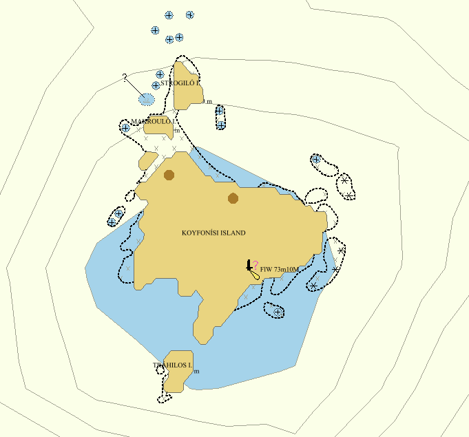
ΝΟΤΙΟ ΑΝΑΤΟΛΙΚΟ ΑΙΓΑΙΟ.ΝΗΣΟΣ ΝΙΣΥΡΟΣ. ΑΠΑΓΟΡΕΥΣΗ ΔΙΕΛΕΥΣΗΣ , ΑΛΙΕΙΑΣ ΚΑΙ ΑΓΚΥΡΟΒΟΛΙΑΣ ΟΛΩΝ ΤΩΝ ΠΛΟΙΩΝ ΚΑΙ ΣΚΑΦΩΝ 100 ΜΕΤΡΩΝ ΑΠΟ ΤΟ ΣΤΙΓΜΑ : 36 37,04Β - 027 09,45Α

The Hellenic Navy Hydrographic Service (HNHS) compiles Additional Military Layers (AMLs) to support the Hellenic Navy operational needs.
AML (Additional Military Layers) is a NATO standard ratified under STANAG 7170 and is defined as:
“...a unified range of digital geospatial data products designed to satisfy the totality of NATO non navigational maritime defense requirements’’
AMLs are sets of geospatial data products for the publication and exchange of all types of:
- Hydrographic information beyond that necessary solely for maritime navigation as defined by International Convention for the Safety of Life at Sea (SOLAS), 1974, Chapter V.
- Oceanographic climatological information
- Meteorological climatological information
The basic AML layers produced by HNHS are:
Vector:
- CLB (Contour Line Bathymetry)
- ESB (Environment, Seabed and Beach)
- LBO (Large Bottom Objects)
- MFF (Maritime Foundation and Facilities)
- RAL (Routes, Areas and Limits)
- SBO (Small Bottom Objects

Η Υδρογραφική Υπηρεσία (ΥΥ) κατασκευάζει Επιπρόσθετα Θεματικά Επίπεδα (AMLs) για την υποστήριξη των επιχειρησιακών αναγκών του Πολεμικού Ναυτικού.
Τα AMLs (Additional Military Layers) είναι ένα πρότυπο του NATO που επικυρώθηκε στο πλαίσιο της STANAG 7170 και έχει ορισθεί ως:
“…μια ενιαία σειρά προϊόντων γεωχωρικών δεδομένων, που έχουν σχεδιαστεί για να καλύψουν το σύνολο των μη ναυτιλιακών απαιτήσεων θαλασσίου περιβάλλοντος του NATO”
Τα AMLs είναι σύνολα γεωχωρικών δεδομένων για την έκδοση και ανταλλαγή των παρακάτω τύπων πληροφοριών:
- Υδρογραφικές πληροφορίες πέραν αυτών που απαιτούνται για τη ναυτιλία και προσδιορίζονται από τη συνθήκη για την Ασφάλεια της Ζωής στη Θάλασσα (SOLAS).
- Ωκεανογραφικών και Κλιματολογικών πληροφοριών.
- Μετεωρολογικών και Κλιματολογικών πληροφοριών.
Τα βασικά θεματικά επίπεδα AMLs που κατασκευάζει η ΥΥ είναι:
Διανυσματικά:
- CLB (Contour Line Bathymetry)
- ESB (Environment, Seabed and Beach)
- LBO (Large Bottom Objects)
- MFF (Maritime Foundation and Facilities)
- RAL (Routes, Areas and Limits)
- SBO (Small Bottom Objects)
The use of copyright is regulated by national, EU and international legislation, and by the Hydrographic Service’s policy, as established from time to time.
By signing the relevant agreements, the Hydrographic Service grants non-exclusive and non-transferable licenses for the use of its products and software . Breach of the relevant terms constitutes infringment of intellectual property rights or copyright, and legal remedies may be sought to protect these rights.
All material, including images, software, text and graphics, keys, keywords and labels, contained in the Site are copyright protected. Viewing and printing the contents of this site and distributing the documents it links to is permitted, provided that such documents will not be used for commercial or personal use, but solely for information purposes. The exchange, modification, sale, transmission or other commercial use of any information contained in this site is prohibited.
If any messages or material are sent by email or otherwise to this site, all such messages will be treated as non-confidential and non-exclusive, unless otherwise classified. The HS will have the right to freely use any concepts, ideals, learning methods or techniques that may be contained in messages sent to the site for any reason, without any compensation to the sender. However, the user agrees and understands that the HS will not be required to use any such ideas or material, and that the sender may not insist on any such use.
Αγγελίες για τους ναυτιλλόμενους (Hellenic Notices to Mariners)
Είναι οι πληροφορίες που παρέχονται με σκοπό να διατηρούν διαρκώς ενήμερους τους Ναυτικούς Χάρτες και τις Ναυτιλιακές Εκδόσεις. Οι Αγγελίες εκδίδονται από την Υδρογραφική Υπηρεσία και διατίθενται δωρεάν στο δικτυακό τόπο της ΥΥ: www.hnhs.gr.
Διακρίνονται σε :
α.Ετήσιες (Μόνιμες)
Εκδίδονται με ετήσιο τεύχος που κυκλοφορεί στις αρχές κάθε έτους, από την ΥΥ. Παρέχει πληροφορίες μόνιμης φύσεως (πχ πεδία βολής και ασκήσεων του Στρατού Ξηράς, Πολεμικού Ναυτικού και Πολεμικής Αεροπορίας, περιοχή έρευνας και διάσωσης της Ελλάδας, περιοχές δικαιοδοσίας ελληνικών σταθμών NAVTEX κλπ).
β.Αγγελίες για τους ναυτιλλόμενους (Μηνιαίο τεύχος)
Εκδίδονται με μηνιαίο τεύχος Αγγελιών που κυκλοφορεί στο τέλος κάθε μήνα, από την Υδρογραφική Υπηρεσία παρέχει πληροφορίες μόνιμης φύσεως (π.χ. θαλάσσιοι κίνδυνοι, ναυάγια, αβαθή, μεταβολές καταστάσεως λιμένων, λειτουργία νέων πυρσών, αλλαγή χαρακτηριστικών πυρσών κλπ) και πρέπει να καταχωρούνται στους Ναυτικούς χάρτες και τις Ναυτιλιακές εκδόσεις. Όταν απαιτείται (μεγάλες αλλαγές στα στοιχεία των χαρτών) οι αγγελίες αυτές συνοδεύονται από μικρά τμήματα χαρτών, γνωστά σαν «επικολλήματα» (BLOCKS) τα οποία πρέπει να τοποθετούνται (κολλιούνται) στον αντίστοιχο Ναυτικό χάρτη.
Για τις διορθώσεις των Ναυτικών Χαρτών πρέπει να χρησιμοποιούνται πάντοτε τα σύμβολα και οι επιτμήσεις του ΧΕΕ 64.


